
Plik:Wales in the UK and Europe.svg

Wielkość pliku podglądu PNG dla pliku SVG: 713 × 600 pikseli Inne rozdzielczości: 285 × 240 pikseli | 571 × 480 pikseli | 913 × 768 pikseli | 1218 × 1024 pikseli | 2435 × 2048 pikseli | 2045 × 1720 pikseli.
Rozmiar pierwotny (Plik SVG, nominalnie 2045 × 1720 pikseli, rozmiar pliku: 7,84 MB)
| Plik Wales in the UK and Europe.svg znajduje się w Wikimedia Commons – repozytorium wolnych zasobów. Dane z jego strony opisu znajdują się poniżej. |
Opis
| Opis |
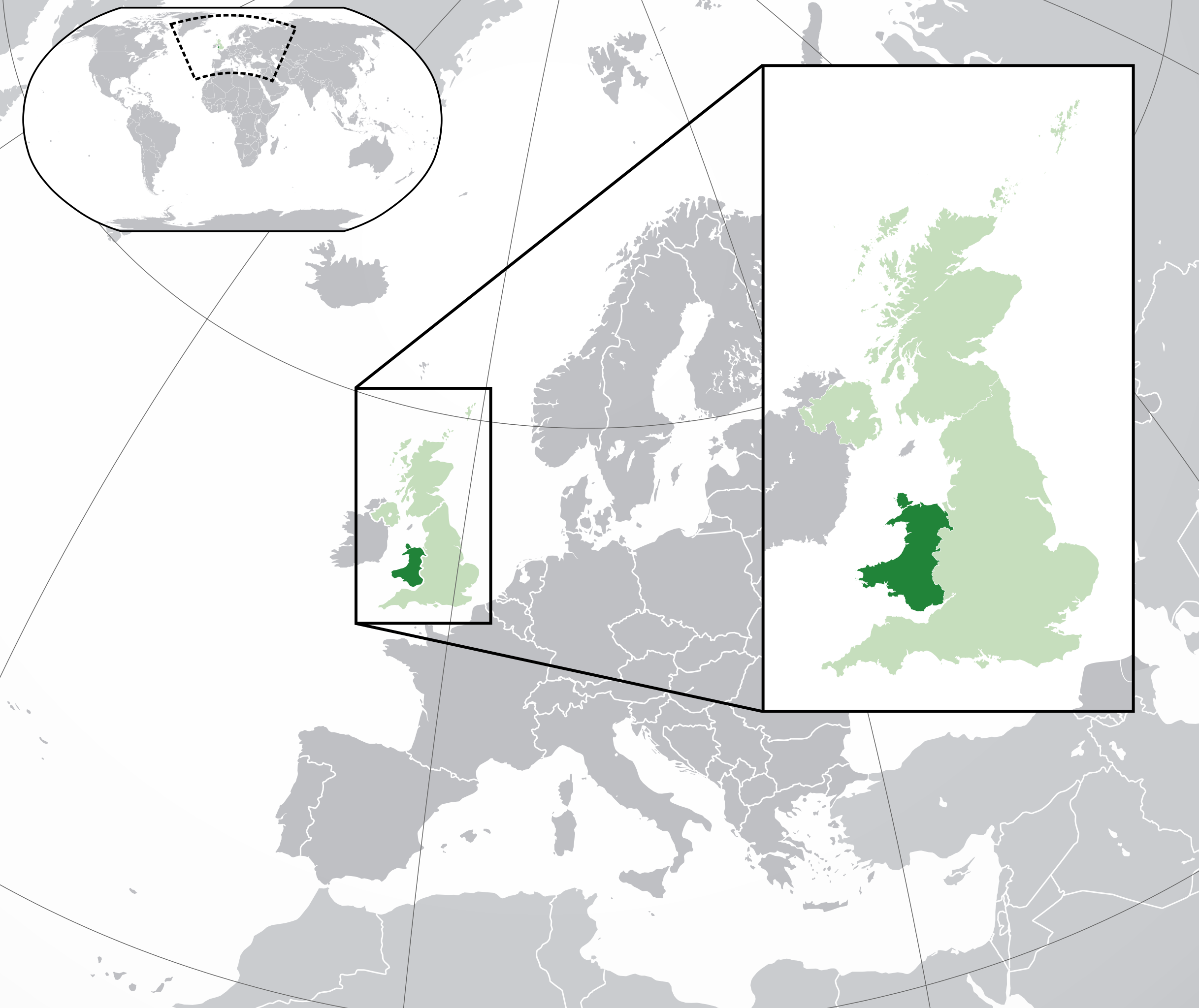
English: A map of Wales within the United Kingdom and Europe. The map is a polar orthographic projection.
Wales
United Kingdom (except Wales)
Europe (except UK) Français : Une carte du Pays de Galles au sein du Royaume-Uni et en Europe. La carte est un polair projection orthographique.
Pays de Galles
Royaume-Uni (sauf le Pays de Galles)
Europe (sauf le Royaume-Uni) Deutsch: Eine Karte der Wales drinnen das Vereinigtes Königreich und drinnen Europa. Die Karte ist ein polare orthografische Azimutalprojektion.
Wales
Vereinigtes Königreich (außer Wales)
Europa (außer das Vereinigtes Königreich) Cymraeg:
Cymru
Y Deyrnas Unedig
Ewrop Gàidhlig:
A' Chuimrigh
An Rìoghachd Aonaichte
An Roinn-Eòrpa Gaeilge:
An Bhreatain Bheag
An Ríocht Aontaithe
An Eoraip Kernowek: Kembra
Ruwvaneth Unys
Europa |
| Data | (UTC) |
| Źródło |
Ten plik jest pochodną pracą: Blank map of Europe (with disputed regions).svg: |
| Autor |
|
| Inne wersje |
|
| SVG rozwój | Ta niezgodna z W3C wielka mapa została stworzona za pomocą Inkscape, or with something else. |


.svg)
Licencja
Ten plik udostępniony jest na licencji Creative Commons Uznanie autorstwa – Na tych samych warunkach 3.0.
- Wolno:
- dzielić się – kopiować, rozpowszechniać, odtwarzać i wykonywać utwór
- modyfikować – tworzyć utwory zależne
- Na następujących warunkach:
- uznanie autorstwa – musisz określić autorstwo utworu, podać link do licencji, a także wskazać czy utwór został zmieniony. Możesz to zrobić w każdy rozsądny sposób, o ile nie będzie to sugerować, że licencjodawca popiera Ciebie lub Twoje użycie utworu.
- na tych samych warunkach – Jeśli zmienia się lub przekształca niniejszy utwór, lub tworzy inny na jego podstawie, można rozpowszechniać powstały w ten sposób nowy utwór tylko na podstawie tej samej lub podobnej licencji.
Oryginalny rejestr przesyłania
This image is a derivative work of the following images:
- File:Blank_map_of_Europe.svg licensed with Cc-by-sa-2.5
- 2012-02-21T16:27:27Z Alphathon 680x520 (614699 Bytes) Updated Metadata and the boarders/coastlines along the western coast of the Black Sea
- 2011-09-19T22:57:58Z Alphathon 680x520 (603759 Bytes) Added North/Northern Cyprus
- 2011-08-23T10:26:48Z Heb 680x520 (604212 Bytes) Added [[:en:Bornholm]] (taken from [[:File:Denmark blank map.svg]])
- 2011-04-12T00:40:40Z Alphathon 680x520 (602549 Bytes) Upgraded Sicily based on "File:Freeworldmaps-sicily.jpg". Upgraded Malta based on "File:Map of Malta 2.png". Simplified Croatian borders.
- 2011-04-10T21:43:04Z Alphathon 680x520 (607359 Bytes) Upgraded Croatia, Bosnia & Herzegovina, Slovenia and surrounding countries based on data from "File:Kroatien - Politische Gliederung (Karte).png"
- 2011-04-10T20:05:09Z Alphathon 680x520 (568373 Bytes) Improved Serbia, Montenegro and surrounding countries using data from "File:Serbia Map.png". Fixed Serbia-Montenegro border. Added Kosovo (using dashed border, since it is not a universally recognised nation, and left the lan
- 2011-04-10T15:55:02Z Alphathon 680x520 (524980 Bytes) Tweaked Ukraine and surrounding countries based on data from "File:Up-map.png"
- 2011-04-10T04:02:09Z Alphathon 680x520 (511168 Bytes) Improved Greece, Albania, F.Y.R. Macedonia and Bulgaria based on "File:Greece topo.jpg"
- 2011-04-10T02:48:52Z Alphathon 680x520 (505569 Bytes) Tweaked Germany and surrounding countries based on info from "File:Germany_general_map.png"
- 2011-04-10T01:54:05Z Alphathon 680x520 (493733 Bytes) Converted all lakes back to separate layer. Added Finish lakes and tweaked Finland shape based on "File:Finland 1996 CIA map.jpg". Added Swiss lakes based on "File:Suisse cantons.svg". Tweaked Scotland and added Lochs.
- 2011-04-10T00:07:54Z Alphathon 680x520 (450120 Bytes) Improved England outline and added Isle of Wight based on "File:England Regions - Blank.svg". Improved Denmark based on "File:2 digit postcode danmark.png". Improved Sweden based on "File:Map of Sweden, CIA, 1996.jpg"
- 2011-04-08T15:53:07Z Alphathon 680x520 (438878 Bytes) Upgraded/fixed various parts of the map. Details: *Some minor fixes to Ireland and added some of the larger lakes based on [[:File:Ireland_trad_counties_named.svg]] *Pretty major fixes to Scotland (mainly the west coast and i
- 2008-09-17T09:50:25Z F7 680x520 (531491 Bytes)
- 2008-09-17T09:42:57Z F7 680x520 (2353 Bytes)
- 2008-05-26T19:04:07Z Collard 680x520 (531491 Bytes) uploading on behalf of [[User:Checkit]], direct complaints to him plox: 'Moved countries out of the "outlines" group, removed "outlines" style class, remove separate style information for Russia'
- 2008-04-30T01:38:52Z TimothyBourke 680x520 (531767 Bytes) Changed the country code of Serbia to RS per [http://en.wikipedia.org/wiki/Serbian_country_codes] and the file [http://www.iso.org/iso/iso3166_en_code_lists.txt].
- 2008-02-08T22:44:37Z CarolSpears 680x520 (531767 Bytes) validated
- 2007-07-10T11:47:59Z MrWeeble 680x520 (533112 Bytes) Updated to include British Crown Dependencies as seperate entities and regroup them as "British Islands", with some simplifications to the XML and CSS
- 2007-05-14T17:17:34Z Zirland 680x520 (540659 Bytes) serbia and montenegro
- 2007-03-30T20:40:49Z W!B: 680x520 (538830 Bytes) minor corr: update nl:Ijsselmeer, del fi:lakes (all small), add ru:lake Oneka (all ref maps.google), glued northern irland back to ie ;)
- 2007-02-05T18:44:32Z Maix 680x520 (538295 Bytes) cropped
- 2007-02-04T15:07:29Z Maix 680x520 (538310 Bytes) {{Information |Description=A blank Map of Europe in SVG format. Every country has an id which is its ISO-3116-1-ALPHA2 code in lower case for easy coloring. |Source=Image based on [[Image:Europe_countries.svg|]] by [[User:Ti
Uploaded with derivativeFX
Historia pliku
Kliknij na datę/czas, aby zobaczyć, jak plik wyglądał w tym czasie.
| Data i czas | Miniatura | Wymiary | Użytkownik | Opis | |
|---|---|---|---|---|---|
| aktualny | 22:00, 6 sie 2014 | | 2045 × 1720 (7,84 MB) | Rob984 | Improved version: More accurate coastline, borders, etc. Added Gradient and Longitude and latitude lines. Zoom insert centred on UK. |
| 16:58, 21 lut 2014 |  | 680 × 520 (2,48 MB) | Rob984 | White background so that the edge of the map is clear. Consistency with other European countries' maps also. | |
| 20:35, 19 sty 2013 |  | 680 × 520 (2,46 MB) | Alphathon | Added Robinson projection to the top left corner. | |
| 01:37, 27 lut 2012 |  | 680 × 520 (941 KB) | Alphathon | Fixed XML | |
| 01:35, 27 lut 2012 |  | 680 × 520 (941 KB) | Alphathon | More detailed British Isles | |
| 02:35, 26 lut 2012 |  | 680 × 520 (790 KB) | Alphathon | Added missing parts of Belgium and the Netherlands. | |
| 00:36, 26 lut 2012 |  | 680 × 520 (806 KB) | Alphathon | == {{int:filedesc}} == {{Information |Description={{en|A map of Wales (dark green) within the United Kingdom (dark and light green) and Europe (dark green, light green and darker grey).}} |Source={{Derived from|Blank_map_of_Europe.svg|display=50}} |Dat... |
Lokalne wykorzystanie pliku
Poniższa strona korzysta z tego pliku:
Globalne wykorzystanie pliku
Ten plik jest wykorzystywany także w innych projektach wiki:
- Wykorzystanie na af.wikipedia.org
- Wykorzystanie na af.wiktionary.org
- Wykorzystanie na am.wikipedia.org
- Wykorzystanie na ar.wikipedia.org
- Wykorzystanie na arz.wikipedia.org
- Wykorzystanie na be.wikipedia.org
- Wykorzystanie na bew.wikipedia.org
- Wykorzystanie na bg.wikipedia.org
- Wykorzystanie na bh.wikipedia.org
- Wykorzystanie na blk.wikipedia.org
- Wykorzystanie na bs.wikipedia.org
- Wykorzystanie na bxr.wikipedia.org
- Wykorzystanie na cdo.wikipedia.org
- Wykorzystanie na chy.wikipedia.org
- Wykorzystanie na ckb.wikipedia.org
- Wykorzystanie na csb.wikipedia.org
- Wykorzystanie na el.wikipedia.org
- Wykorzystanie na en.wikipedia.org
- Wykorzystanie na en.wikinews.org
- Wykorzystanie na en.wiktionary.org
- Wykorzystanie na es.wikipedia.org
- Wykorzystanie na et.wikipedia.org
- Wykorzystanie na eu.wikipedia.org
- Wykorzystanie na fa.wikipedia.org
- Wykorzystanie na fiu-vro.wikipedia.org
- Wykorzystanie na fi.wikipedia.org
- Wykorzystanie na fi.wiktionary.org
- Wykorzystanie na fr.wikipedia.org
- Wykorzystanie na fy.wikipedia.org
- Wykorzystanie na gd.wiktionary.org
- Wykorzystanie na gn.wikipedia.org
- Wykorzystanie na gu.wikipedia.org
- Wykorzystanie na hak.wikipedia.org
- Wykorzystanie na he.wikivoyage.org
- Wykorzystanie na hi.wikipedia.org
- Wykorzystanie na hr.wikipedia.org
- Wykorzystanie na hr.wiktionary.org
- Wykorzystanie na hu.wikipedia.org
- Wykorzystanie na hy.wikipedia.org
- Wykorzystanie na ia.wikipedia.org
Pokaż listę globalnego wykorzystania tego pliku.