
Plik:Cook chart of Otaheite.jpg

Rozmiar pierwotny (2178 × 1241 pikseli, rozmiar pliku: 1,16 MB, typ MIME: image/jpeg)
| Plik Cook chart of Otaheite.jpg znajduje się w Wikimedia Commons – repozytorium wolnych zasobów. Dane z jego strony opisu znajdują się poniżej. |
Opis
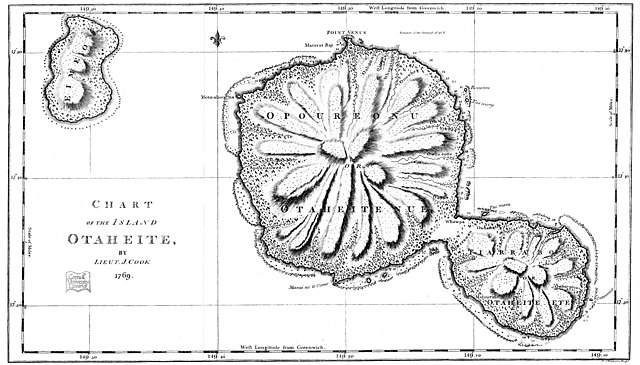
| Opis | This is an facsimile of Lieutenant (later Captain) James Cook's 1769 chart of the island of Otaheite (today called Tahiti). |
| Data | Original created in 1769; this facsimilar published in 1893 |
| Źródło | Taken from the Project Gutenberg edition of Captain Cook's Journal, First Voyage, which is based on an 1893 publication of Cook's original manuscript |
| Autor | |
| Licencja (Ponowne użycie tego pliku) |
It is in the public domain worldwide |
Licencja
|
Ten materiał przeszedł do domeny publicznej w kraju pochodzenia, jak również w państwach i terytoriach, gdzie prawo autorskie wygasa w ciągu 70 lat po śmierci autora.
| |
| Plik rozpoznano jako wolny od znanych ograniczeń praw autorskich, włącznie z prawami zależnymi i pokrewnymi. | |
Historia pliku
Kliknij na datę/czas, aby zobaczyć, jak plik wyglądał w tym czasie.
| Data i czas | Miniatura | Wymiary | Użytkownik | Opis | |
|---|---|---|---|---|---|
| aktualny | 03:58, 6 paź 2021 | | 2178 × 1241 (1,16 MB) | McGhiever | Cleaner copy from Internet Archive (https://ia600205.us.archive.org/view_archive.php?archive=/24/items/cu31924029834946/cu31924029834946_cubook.zip&file=IMAGES%2F31924029834946_000150.JP2&ext=jpg) |
| 07:46, 15 wrz 2006 |  | 1100 × 620 (138 KB) | Hesperian | {{Information |Description=This is an facsimile of Lieutenant (later Captain) James Cook's 1969 chart of the island of Otaheite. |Source=Taken from the Project Gutenberg edition of Captain Cook's Journal, First Voyage, which is based on an 1893 publicatio |
Lokalne wykorzystanie pliku
Poniższa strona korzysta z tego pliku:
Globalne wykorzystanie pliku
Ten plik jest wykorzystywany także w innych projektach wiki:
- Wykorzystanie na en.wikisource.org
- Wykorzystanie na lt.wikipedia.org
- Wykorzystanie na mk.wikipedia.org